
: failed to open stream: Invalid argument in <b>/home/servuzmq/minisites/siteT1/common/template/carteV2.php</b> on line <b>139</b><br />
)
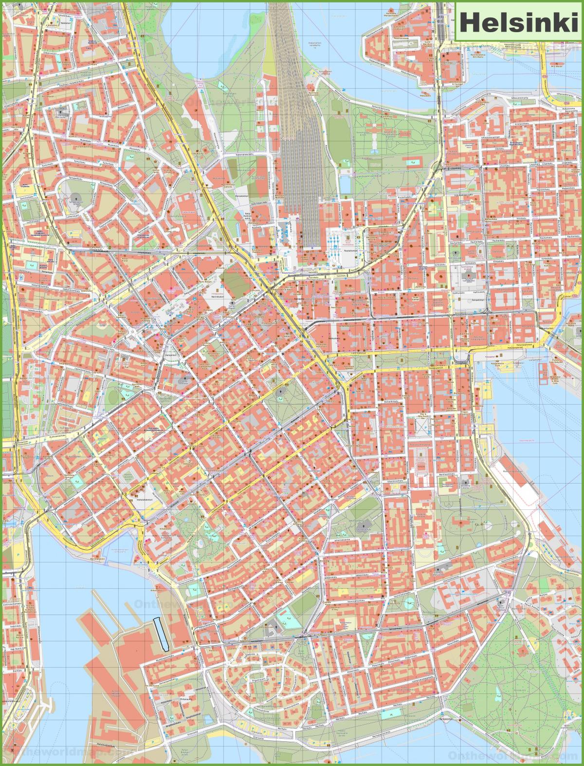
You can find on this page the Helsinki streets map to print and to download in PDF. The Helsinki roads map presents the road network, main roads, routes and motorways of Helsinki in Uusimaa - Finland.
The Helsinki streets map shows all street network and main roads of Helsinki. This streets map of Helsinki will allow you to find your routes through the streets of Helsinki in Uusimaa - Finland. The Helsinki streets map is downloadable in PDF, printable and free.
Street and road numbers are assigned on the basis of detailed plans, changes to detailed plans, plot divisions, changes to plot divisions and for other specific reasons. Street and road numbering in Helsinki is carried out by The Urban Environment Division , whose street number service provides assistance in questions concerning numbering. Names are assigned to streets and roads in connection of the preparation of detailed plans. "Linjat" are the numbered streets of Kallio. On the Kolmas and Neljäs linja as well on their intersection you will find several cafes, bars and ethnic restaurants including as you can see in Helsinki streets map: Chalupa, Lopez y Lopez, Bangkok 9, Lemongrass, Roji and Taqueria El Rey. If you fancy a drink, drop by Oiva, Om’Pu Bar or try Pub Sirdie, which has one of the best atmospheres in Kallio where you can still sense the old working-class spirit.
Mannerheimintie is one of the main streets in Helsinki, it is very wide and leads from Erottaja in the city center where you will find the Swedish theater and the popular Stockman shopping center, then pass by the Töölö area, and the districts of Kamppi and Ruskeasuo, finally reaching a highway that goes out of town. Mannerheimintie as its shown in Helsinki streets map, was originally called Heikinkatu in honor of Heikki Rehbinder, Secretary of State of the Grand Duchy of Finland in 1811-1841, but was renamed after the Winter War in honor of Marshal Mannerheim. There is plenty of attractions along the street: National Museum of Finland, Museum of Contemporary Art Kiasma, the house of Finland, Parliament, statues. Katajanokka, since 1903, the city most weird and funny, spoken by the inhabitants of Helsinki. His long streets modernists raised between 1901 and 1910, are truly a unique gem in the world. Lets take a walk and admire especially the pastel colors and the many forms of windows, towers and outgoing. Enhance especially floral and animal motifs clearly inspired Finnish in door jambs, under the eaves on the roofs.
Lesplanade, the park plaza is very old since it has been 200 years. As at the time, this is a promenade where locals and other tourists come to stroll, picnic, read. This green median between the two lanes of a wide avenue leading from downtown to the Market Square as its mentioned in Helsinki streets map. In summer it is nice to get some fresh air here especially as many events take place such as concerts in the bandstand. Among the huge variety of modernist buildings that face the street Tehtaankatu, one of the most interesting is a large house with a red dome, which is distinguished from afar. Its walls are like a natural landscape, with all textures representing Finland: A free composition of granite, plaster reliefs spiral lichen and windows framed in red brick. It is a welcoming building and if we remove both original coldness prejudices seem to inspire the building contrary to the Mediterranean tastes.
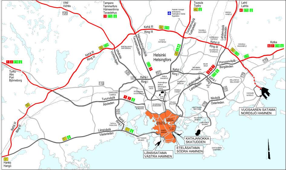
The Helsinki roads map shows all road network and highways of Helsinki. This roads map of Helsinki will allow you to find your routes through the roads and motorways of Helsinki in Uusimaa - Finland. The Helsinki roads map is downloadable in PDF, printable and free.
The backbone of Helsinki motorway network consists of three semicircular ring roads, Ring I, Ring II, and Ring III, which connect together expressways heading to other parts of Finland, and the western and eastern arteries of Länsiväylä and Itäväylä respectively as you can see in Helsinki roads map. While variants of a Keskustatunneli tunnel under the city centre have been repeatedly proposed, as of 2011 the plan remains on the drawing board. Helsinki has some 390 cars per 1000 inhabitants. This is less than in cities of similar density, for instance, Brussels 483 per 1000 and Stockholm 401, and Oslo 413.
As the name of the route already reveals, this tour is meant for travelers who are interested in life style, culture, history and exciting cultural events and sights. The route for Culture Lovers is approximately 1300 km long and travels through Helsinki to Finnish Lakeland as its shown in Helsinki roads map. It includes the regions of Kouvola, Mikkeli, Savonlinna, Jyväskylä and Tampere regions. The most popular sight in Savonlinna is the medieval Olavinlinna Castle – perfect destination for a Culture Lover. Roller skating route from Helsinki Ring 1 road to Tuusula airport road and further towards Ring 3 and then towards Hämeenlinna road and then back to Ring 1. Route is such that you can not cut the corners when no point of return point has been passed. Has one long downhill and one long uphill. Those are not too bad or challenging. Has 2 service points. Valintatalo shop in Ylästö for some refreshments.
There are about 930 kilometres of motorways. With some minor exceptions, they are dual carriageways with 2+2 lanes. There are six motorways originating radially from Helsinki having the total length of 700 kilometres as its mentioned in Helsinki roads map. The other motorways are rather short sections close to the biggest cities. The motorway section of the road 29 is said to be the northernmost motorway in the world. Most of the other roads are single carriageways with 1+1 lanes. The most notable exceptions to this are the ring roads around Helsinki and Turku. The busiest sections of those are dual carriageway with 2+2 or 3+3 lane setup. In hilly areas, some primary and secondary roads are equipped with uphill fast lanes to help overtaking slow vehicles. A few of these 2+1 roads are equipped with a middle barrier separating the traffic directions. The current road numbering scheme for primary and secondary routes was introduced in 1938. The roads 1 to 7 originated radially clockwise from Helsinki, the roads 8 to 10 from Turku, the roads 11 and 13 from Tampere, and the roads 13 to 15 from Viipuri. The highest primary road was 21. The secondary roads, numbered from 51 to 82, did not follow similar systematic setup. Instead, the numbers grew from south to north. Later, the range of primary road numbers has been extended up to 29, and the number of secondary roads span from 40 to 98.
